Larrie stopped into a Health and Beauty store to buy shampoo. The
proprietor tried to sell him skin lightner. Larrie, quite surprised,
said "You've GOT to be kidding. If I want lighter skin I'll just use
sun screen!"
June 29, 2009
June 25, 2009
Happy Trails
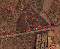
After the June 21 bike ride, which I was surprisingly asked to navigate, I decided to compile the library of all the GPS data on rides the Palm Meadows group has done since I joined the group in December 2008. I have not done all the rides, but I have done a lot of them. Google Earth allows the compilation of all this data, and you can turn on / off individual rides like layers in a picture. So, after uploading all the GPS data into Google Earth, I turned on all the ride data, and I got a picture that I call Happy Trails.
Some of the longer rides that others in the group have done go out of the picture due to the scale of the picture. Palm Meadows is by Ramagondanahalli in the left-center of the picture. Jessica's school is the white spot South of Hegondanahalli, which is due South of Ramagondanahalli. Bengaluru proper is West and out of the picture. Most of the rides are in farm country and through the various villiages. Those trails traveled frequently are brighter red. Likewise, those trails that are not are not so thick and red.
Years ago, Alli and I ran into a poem called The Calf Path, by Sam Walter Foss. After my commentary on the June 14 ride following cow paths, Arun had responded that indeed, many of the paths in India are exactly that - people following where the cattle went. And anyone who has ever been around cattle know that they do not walk in a straight line. At any rate, looking at my composition photo of the trails reminded me of the poem, and I had to re-read it. I am now pondering the poignantcy of the contrast of the picture and the poem.
June 21, 2009
Alexandria Mikhaela Bleu: much loved 1989-2009
.jpg)
Xander aka. "Boo Bear" aka. "Turtle Ears" aka. "Xandee Boo"
Twenty years ago I called all over the state of Montana to find a Himalayan kitten. My friend had a little fuzz ball named Merlin and I decided I needed a copy cat. By luck, I had a meeting to attend in Missoula and there you were at the local petshop. The moment I laid eyes on you, I knew you were coming home with me. Jasmine didn't look at me, meow at me, or forgive me for three weeks.
You soon displayed your fetching talent: paper being your medium of choice, closely followed by rubber bands. And wow, could you jump. Your gymnastic talent has never been surpassed by any other cat in the household.
I remember with joy the night your kittens were born. Unlike the expectation that had been set that you would go off to a dark, solitary place to have your kittens, you wanted me near you and followed me throughout the house while you were laboring. Three beautiful kittens became part of our family for the next two months. Happily Clarence Alabaster Tuttle (CAT) went off to live with a great friend and we got to see your son grow up through the years. He was a little bitty mite, just like you.
I always wondered how such a small kitty could have such heavy feet. You would stomp on me as I was going to sleep at night and you felt like you must be the size of a lion. And how could such a big purr come out of you?
I still think you swallowed one of my ruby earrings nursing on my ear when you were just a baby kitten. It was very startling to wake up to my ear being all slobbery and a rumbling purr hitting my ears drum.
And I'll probably always recall tripping over you and bumping down the stairs. I didn't want to hurt you or break a 30 cent kitchen glass. I still woudn't have wanted to hurt you, but I sure would have traded that drinking glass for the bruise on my tail bone for the next 6 months.
You seemed to really enjoy being a cabin cat. Over the years you mellowed out and became a silent traveler. When we moved from Montana to Minnesota you were hoarse from meowing for 19 hours straight.
I still regret taking away your pleasure of sleeping in your blue cushion. Had I known by putting Max in it, in an attempt at introducing her to you, would result in you never getting in it again, I would have never had done that. I'm also sorry for the time I forgot you were outside and you were stuck swinging from the porch by your halter in the rain.
.JPG) I'm glad you got to enjoy so much outdoor time with Gramcat and Grampcat the last few months. For years, being outside seemed to be your favorite activity whiling away the hours in the warm sun.
I'm glad you got to enjoy so much outdoor time with Gramcat and Grampcat the last few months. For years, being outside seemed to be your favorite activity whiling away the hours in the warm sun.Xander, your paw prints will forever remain upon my heart. Thank you for sharing the past 20 years with me. I wish I would have been home this spring to pet you, hug you, and be stomped on by you, just one more time. May cat heaven be filled with cat nip, tender grass shoots, sun beams, soft cushions, and stacks of yellow open cans of Gorton Clams. I miss you, I love you. Goodbye. -allison
June 15, 2009
It Started Out To Be a Nice Ride
This past Sunday was Larrie's first (and probably his last) attempt at leading the Sunday morning bicycle group on a ride. While in the US, Larrie purchased a GPS to use while riding in India due to the fact that he wanted a backup plan to get home - not that the group had ever lost anyone, you see, but predicting the future is tricky business requiring risk mitigation. On June 7, Larrie attempted to follow the predicted ride using the GPS, only to discover just how difficult a task this is to do while riding hither and yon dodging the dogs, chickens, potholes, trees, ditches, and, well, you get the idea. And given the fact that the group leader got lost on this same trip, it occurred to Larrie that the true value of the GPS device is to get one unlost, which is not the same as being found.
Segue: An old business associate of Larrie's, who was an actuary joked that when he traveled by plane (this was in the mid-1970's), he took his own bomb. He claimed that the odds of two people having a bomb on the same plane were astronomical; therefore, he was assuring a safe trip. Quite possibley, and for the same reason, it is necessary to have two GPS on a ride; however, with our group it also requires a GPS enabled iPhone to even out the odds of a safe return. End seque.
Larrie spent the week of June 7-14 creating a new track and vetting it both on the ground and with others in the group. The goal was to get to a eucalyptus forest that is East of the train tracks and the object of the January 18 ride. Using Google Earth, a gross track was laid out, and then the details were filled in. A total of 348 points were plotted using Google Earth, which should have provided sufficient details to assure a leisurely ride; however, a cautionary note about online imagery - it's old, and we humans continue to shape our environment constantly, and damned if the trees don't grow and get harvested - change is ever persistant. So, a nice trail through the forest one sees in the online imagery now bisects a farm that has a six foot granite fence around it. Also, it is interesting how cow paths look remarkably like viable trails in an image genereated from high above the earth.
Now, anyone who knows Larrie knows that simple is not common in his vocabulary. Alli refers him as the great complexifier. Case in point: Google Earth exchanges its data in a file format known as .kml, which is an attribute rich xml file. However, Google Earth is the only user of that format, and GPS uses a standard format known as .gpx. A conversion utility was required to translate one file format to another. Simple; no problemo. The solution required the creation of a file conversion utility thereby enabling upload of said .kml data into the GPS (online utilities were found to be lacking or not workable / usable). The converstion utility took a bit of coding, but perserverance was repaid with an GPS acceptable .gpx file.
Normally, the group navigator uses MapMyRide.com create new tracks, which are then uploaded into a GPS for ride navigation. At the conclusion of a ride, the navigator uses MapMyRide to import actual GPS ride data, which can then be exported to Google Earth. Heres the thing - MapMyRide uses Google imagery, but it does not allow as fine grained zoom as does Google Earth. Hence, the reason Larrie choose Google Earth, and the reason the data required conversion. Said conversion tool was created, track converted, and loaded into GPS for testing and use. Simple, in a complex way.
The loaded track was tested. The first 6km, and the last 10km were tested by on the ground navigation, and success was achieved resulting in a wary and false bravado on the part of the fledgling navigator. The track was fine tuned with new points, and the final version was converted and loaded into the GPS for the Sunday ride, which was predicted as around 42-43 km. in length.
In the ride post mortem, group leader Arun Katiyar generously stated that it was a "brave" track, but the truth be known that comparing the predicted to actual ride data indicated that we were off the track more than we were on the track. If it had not been for others in the group with on the ground knowledge of roads and destinations, and pretty good navigators, we would still be out in the outback slogging through thorny brush in search of the proper path, rather than the freshly marked cow path that we were following - on foot no less as we could not ride through the bramble. Our arms shredded by the thorns, bleeding, spirits deflated, we finally emerged at the forest exit underpass. Somewhere in this scenario, Arun chose to tell the group of the thrill of biking through Jeruselem. Quite possibly the thought of thorns, bleeding brought out the image of resurrection at the underpass. Just a thought.
 While searching for the path out of the thorny brush, someone commented that we had discovered the "Bermuda Triangle" of the area, and when looking at the actual ride map, the lines traced by this particular "lost" episode did loosely resemble a devilish figure; so, who knows... In total, we did 46km over 6 hours burning up 1,772 calories, and everyone was ever so glad to get home and get off their bikes even though member of the group served up some great trail food in the form of angioplasty ready ghee based sweets amoungst biscuits and bars.
NTSB, who reviews all transportation related safety errors, is still reviewing the recordings from the trip black box. An error was discovered in the Google Earth track data, which created a "loop" in the track, but that in and of itself did not create the chaos. Artifacts such as the GPS accuracy, which is +- 19m, and the level of zoom in have been considered. Also, the particular view of the navigator using the GPS (follow the road map) vs. other views (such as a compass)offered by the device are all under review. It should be noted that there are no topographical maps for India; so getting detailed GPS data as we enjoy in the USA is just not possible. And, finally, as pointed out by Alli, perhaps Larrie needs bifocal sunglasses to read the small GPS screen - just perhaps.

Theories avail and testing remains, but root causes are elusive. Needless to say, it is doubtful the group will ask Larrie to create a new ride and lead them anywhere, anytime soon. Maybe they should just hire a cow, they seem to know where they're going - their trails are everywhere, and the trails are pretty well marked. I wonder if Google ever considered putting GPS transponders on the cows....
Larrie spent the week of June 7-14 creating a new track and vetting it both on the ground and with others in the group. The goal was to get to a eucalyptus forest that is East of the train tracks and the object of the January 18 ride. Using Google Earth, a gross track was laid out, and then the details were filled in. A total of 348 points were plotted using Google Earth, which should have provided sufficient details to assure a leisurely ride; however, a cautionary note about online imagery - it's old, and we humans continue to shape our environment constantly, and damned if the trees don't grow and get harvested - change is ever persistant. So, a nice trail through the forest one sees in the online imagery now bisects a farm that has a six foot granite fence around it. Also, it is interesting how cow paths look remarkably like viable trails in an image genereated from high above the earth.
Now, anyone who knows Larrie knows that simple is not common in his vocabulary. Alli refers him as the great complexifier. Case in point: Google Earth exchanges its data in a file format known as .kml, which is an attribute rich xml file. However, Google Earth is the only user of that format, and GPS uses a standard format known as .gpx. A conversion utility was required to translate one file format to another. Simple; no problemo. The solution required the creation of a file conversion utility thereby enabling upload of said .kml data into the GPS (online utilities were found to be lacking or not workable / usable). The converstion utility took a bit of coding, but perserverance was repaid with an GPS acceptable .gpx file.
Normally, the group navigator uses MapMyRide.com create new tracks, which are then uploaded into a GPS for ride navigation. At the conclusion of a ride, the navigator uses MapMyRide to import actual GPS ride data, which can then be exported to Google Earth. Heres the thing - MapMyRide uses Google imagery, but it does not allow as fine grained zoom as does Google Earth. Hence, the reason Larrie choose Google Earth, and the reason the data required conversion. Said conversion tool was created, track converted, and loaded into GPS for testing and use. Simple, in a complex way.
The loaded track was tested. The first 6km, and the last 10km were tested by on the ground navigation, and success was achieved resulting in a wary and false bravado on the part of the fledgling navigator. The track was fine tuned with new points, and the final version was converted and loaded into the GPS for the Sunday ride, which was predicted as around 42-43 km. in length.
In the ride post mortem, group leader Arun Katiyar generously stated that it was a "brave" track, but the truth be known that comparing the predicted to actual ride data indicated that we were off the track more than we were on the track. If it had not
been for others in the group with on the ground knowledge of roads and destinations, and pretty good navigators, we would still be out in the outback slogging through thorny brush in search of the proper path, rather than the freshly marked cow path that we were following - on foot no less as we could not ride through the bramble. Our arms shredded by the thorns, bleeding, spirits deflated, we finally emerged at the forest exit underpass. Somewhere in this scenario, Arun chose to tell the group of the thrill of biking through Jeruselem. Quite possibly the thought of thorns, bleeding brought out the image of resurrection at the underpass. Just a thought.While searching for the path out of the thorny brush, someone commented that we had discovered the "Bermuda Triangle" of the area, and when looking at the actual ride map, the lines traced by this particular "lost" episode did loosely resemble a devilish figure; so, who knows... In total, we did 46km over 6 hours burning up 1,772 calories, and everyone was ever so glad to get home and get off their bikes even though member of the group served up some great trail food in the form of angioplasty ready ghee based sweets amoungst biscuits and bars. NTSB, who reviews all transportation related safety errors, is still reviewing the recordings from the trip black box. An error was discovered in the Google Earth track data, which created a "loop" in the track, but that in and of itself did not create the chaos. Artifacts such as the GPS accuracy, which is +- 19m, and the level of zoom in have been considered. Also, the particular view of the navigator using the GPS (follow the road map) vs. other views (such as a compass)offered by the device are all under review. It should be noted that there are no topographical maps for India; so getting detailed GPS data as we enjoy in the USA is just not possible. And, finally, as pointed out by Alli, perhaps Larrie needs bifocal sunglasses to read the small GPS screen - just perhaps.
But the reality is that while Larrie's navigational skills are at the
apprentice level, Google Earth's ability to map a set of data to it's imagery is off a bit. As is noted in the picture at right, the lines of the proposed to the actual do not match, nor are they close to the imagery provided. (Note: The proposed line is the one with the grey numbers on it.) When the track was plotted, the points mapped to the imagery, but the resulting GPS coordinates were off a bit. So, it could be that Google Earth has a rounding issue - hmmm, wondering if the Google cloud utilizes the old Pentiums that had the division error.
Theories avail and testing remains, but root causes are elusive. Needless to say, it is doubtful the group will ask Larrie to create a new ride and lead them anywhere, anytime soon. Maybe they should just hire a cow, they seem to know where they're going - their trails are everywhere, and the trails are pretty well marked. I wonder if Google ever considered putting GPS transponders on the cows....
June 6, 2009
Why does my Mushroom and Asparagus Risotto have yellow kernals in it?
Went to restaurant at nice hotel. Yummy! An Italian food section on the menu. Yay! No lentils for me today. Order Mushroom and Aspragus Risotto. Get order. Look at it. Wonder: Why is there yellow stuff in it but no green stuff? Talk to waiter.
me: "I ordered Mushroom and Asparagus Risotto".
waiter: "Yes, maam".
me: "This isn't Mushroom and Asparagus".
waiter: "Yes, it is, maam".
me: "Where is the asparagus?"
waiter: "It's not in season".
I now realize this is an acceptable and common practice here: If plan A is not possible, simply go on to plan B. Don't mention you are going with plan B, just show up with something different. I mean... corn is still a vegetable, right? That should be just fine instead of asparagus in risotto, right? There's no need to go back and find out if my customer would like to order something else.
NOT! I won't ever be purposefully ordering Mushroom and Corn Risotto. Bluck!
Since when is h-a-m pronounced Pepperoni???
Recent order to Dominoes Pizza: "I'd like a mushroom, olive, capsicum (green pepper), tomato, and ham pizza, please."
Response: "Do you want cheese?" I guess I'd thought that was a given.
My answer: "Yes, cheese too"
Response: "A margherita pizza?"
Me: "No, mushroom, olive, capsicum, tomato, and ham"
Response; "on margherita" Ok, now I get it. Order the base cheese pizza and add the rest. Makes for a nice expensive pizza.
Me: "Yes"
Response: "you had pepperoni last time" How nice that big brother Dominos is tracking what I'm eating.
Me: "Yes"
Response: "you want pepperoni?"
Me: "No, I want ham"
Me: "No, I want ham"
Response: "the pepperoni was fine?"
Me: "Yes, but ham this time"
Response: "pepperoni was ok?"
Me: "YES"
Response: "magherita, mushroom, olive, capsicum, tomato, and pepperoni?"
Me: "NO!, HAM!"
Response: "you like pepperoni?"
Me: "Yes, it was fine"
Response: "ok, I'll give you pepperoni"
Me, giving up: "fine"
Later it dawned on me, the person taking my order was probably thinking "How many FLIPPIN' ways do I have to tell her we are OUT of HAM???" Discussions are circuitous here and nobody wants to disappoint, therefore options are offered in place of saying something is not possible.
Subscribe to:
Posts (Atom)
.JPG)